File: Triple Occupation of Greece.png

Size of this preview: 588 × 600 pixels. Other resolutions: 235 × 240 pixels | 471 × 480 pixels | 899 × 917 pixels.
Original file (899 × 917 pixels, file size: 186 KB, MIME type: image/png)
Summary
| Description |
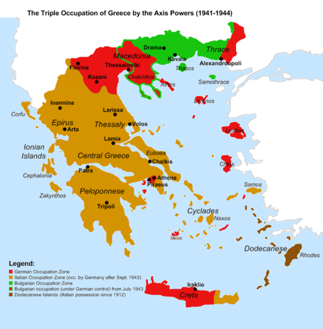
English: Map of the 1941-1944 Axis Occupation of Greece. Depicted are the three occupation zones, plus the geographic regions and major urban centres. |
| Date | |
| Source |
Own work based on: Gr-triple-occupation.png, with minor corrections in the territorial extent of the occupation zones, and added information. References:
|
| Author | Cplakidas |
| Other versions |
[]
|




Licensing

|
Permission is granted to copy, distribute and/or modify this document under the terms of the GNU Free Documentation License, Version 1.2 or any later version published by the Free Software Foundation; with no Invariant Sections, no Front-Cover Texts, and no Back-Cover Texts. A copy of the license is included in the section entitled GNU Free Documentation License. |
  
|
This file is licensed under the Creative Commons Attribution-Share Alike 3.0 Unported license. | |
| ||
| This licensing tag was added to this file as part of the GFDL licensing update. |
File history
Click on a date/time to view the file as it appeared at that time.
| Date/Time | Thumbnail | Dimensions | User | Comment | |
|---|---|---|---|---|---|
| current | 15:52, 6 June 2021 | | 899 × 917 (186 KB) | wikimediacommons>Hohum | Avoiding blue for land areas |
File usage
The following page uses this file:
