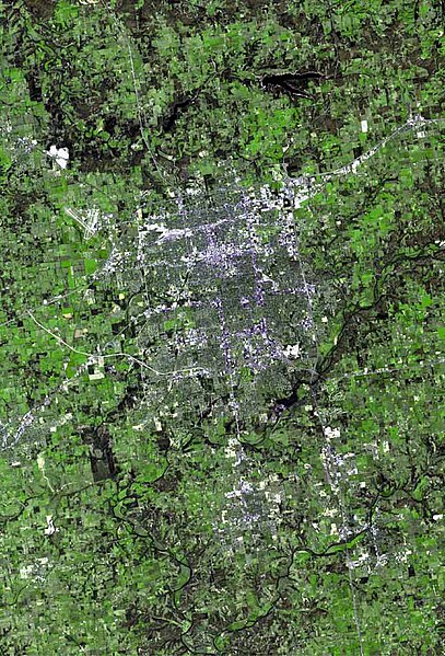
File: Springfield mo aerial map.jpg

Size of this preview: 407 × 599 pixels. Other resolutions: 163 × 240 pixels | 576 × 848 pixels.
Original file (576 × 848 pixels, file size: 112 KB, MIME type: image/jpeg)
| Description | The raw satellite imagery shown in these images was obtain from NASA and/or the US Geological Survey. Post-processing and production by www.terraprints.com |
| Date | |
| Source | www.terraprints.com |
| Author | http://www.terraprints.com |
This file is licensed under the Creative Commons Attribution 2.5 Generic license.
- You are free:
- to share – to copy, distribute and transmit the work
- to remix – to adapt the work
- Under the following conditions:
- attribution – You must give appropriate credit, provide a link to the license, and indicate if changes were made. You may do so in any reasonable manner, but not in any way that suggests the licensor endorses you or your use.
File history
Click on a date/time to view the file as it appeared at that time.
| Date/Time | Thumbnail | Dimensions | User | Comment | |
|---|---|---|---|---|---|
| current | 20:49, 25 February 2011 | | 576 × 848 (112 KB) | wikimediacommons>Ras67 | losslessly cropped with Jpegcrop |
File usage
The following page uses this file: