File: Six Day War Territories 2.png
No higher resolution available.
Six_Day_War_Territories_2.png (398 × 599 pixels, file size: 52 KB, MIME type: image/png)
Summary

|
File:Six Day War Terrritories.svg is a vector version of this file. It should be used in place of this PNG file when not inferior.
File:Six Day War Territories 2.png → File:Six Day War Terrritories.svg
For more information, see Help:SVG. |
 |
| Description |
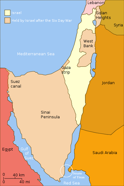
English: Israel and the territories Israel occupied in the Six day war. |
| Date | (UTC) |
| Source | |
| Author |
|
| Other versions |
[]
|


.png)


| This is a retouched picture, which means that it has been digitally altered from its original version. Modifications: Changed "Israeli territory before the Six day war" to "Israel", since Israels territory before the Six day war is the same as after. The original can be viewed here: Six Day War Terrritories.png:
|
I, the copyright holder of this work, hereby publish it under the following license:
This file is licensed under the Creative Commons Attribution-Share Alike 2.5 Generic license.
- You are free:
- to share – to copy, distribute and transmit the work
- to remix – to adapt the work
- Under the following conditions:
- attribution – You must give appropriate credit, provide a link to the license, and indicate if changes were made. You may do so in any reasonable manner, but not in any way that suggests the licensor endorses you or your use.
- share alike – If you remix, transform, or build upon the material, you must distribute your contributions under the same or compatible license as the original.
Original upload log
This image is a derivative work of the following images:
- File:Six_Day_War_Terrritories.png licensed with Cc-by-sa-2.5
- 2010-11-11T21:32:04Z 99of9 398x599 (53810 Bytes) Reverted to version as of 07:04, 25 July 2010. Both POV versions should be at different locations, marked with POV and linked.
- 2010-11-08T11:06:48Z Supreme Deliciousness 398x599 (53223 Bytes) Israeli territory before the Six day war is the same as after the Six day war.
- 2010-07-25T07:04:14Z Ling.Nut 398x599 (53810 Bytes) {{Information |Description={{en|1=Israeli territories before and after the Six Day War. The Straits of Tiran are circled, between the Gulf of Aqaba, and the Red Sea.}} |Source=Yom Kippur War map.svg |Author=[[User:Ling.Nut]]
Uploaded with derivativeFX
File history
Click on a date/time to view the file as it appeared at that time.
| Date/Time | Thumbnail | Dimensions | User | Comment | |
|---|---|---|---|---|---|
| current | 12:15, 12 November 2010 | | 398 × 599 (52 KB) | wikimediacommons>Supreme Deliciousness | {{Information |Description={{en|1=Israel and the territories Israel occupied in the Six day war.</br>in yellow: Israel within the "Green Line" borders (per 1949 ceasefire agreements); in light maroon: Territories Israel seized during |
File usage
The following page uses this file: