File: Map of the African Union with Suspended States.svg

Size of this PNG preview of this SVG file: 600 × 600 pixels. Other resolutions: 240 × 240 pixels | 480 × 480 pixels | 768 × 768 pixels | 1,024 × 1,024 pixels | 2,048 × 2,048 pixels | 1,000 × 1,000 pixels.
Original file (SVG file, nominally 1,000 × 1,000 pixels, file size: 184 KB)
Summary

| Description |
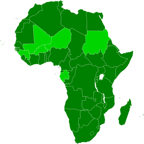
Deutsch: Karte Afrikas mit Mitgliedsstaaten der Afrikanischen Union in dunkelgrün und suspendierten Mitgliedern in hellgrün
Member states Suspended states English: Map of Africa, with African Union member states in dark green, and the states with (former) suspended membership in light green.
Member states Suspended states 日本語: アフリカの地図。アフリカ連合の加盟国は濃い緑で、加盟しているが参加停止処分を受けている国は薄い緑で示している。
加盟 参加停止 Українська: Карта Африки, члени Африканського Союзу позначені темно-зеленим, а країни з призупиненим членством — світло-зеленим
Member states Suspended states Kiswahili: Ramani ya Afrika, nchi wanachama za Umoja wa Afrika zikiwa za kijani kizito, na nchi zenye uanachama uliosimamishwa zikiwa za kijani hafifu.
Member states Suspended states বাংলা: আফ্রিকার মানচিত্র, যেখানে আফ্রিকান ইউনিয়নের বর্তমান সদস্যদের গাঢ় সবুজ রঙে এবং প্রাক্তন সদস্যদের পাতলা সবুজ রঙে চিহ্নিত করা হয়েছে। বর্তমান সদস্যরা প্রাক্তন সদস্যরা |
| Date | |
| Source | Based on information in the African Union article. |
| Author | Patrick Braga |
| Permission (Reusing this file) |
Original: Based on File:Map of the African Union.svg by User:Mangwanani Current: Derivative of File:BlankMap-Africa.svg |
| SVG development |
Licensing
This file is licensed under the Creative Commons Attribution-Share Alike 3.0 Unported license.
- You are free:
- to share – to copy, distribute and transmit the work
- to remix – to adapt the work
- Under the following conditions:
- attribution – You must give appropriate credit, provide a link to the license, and indicate if changes were made. You may do so in any reasonable manner, but not in any way that suggests the licensor endorses you or your use.
- share alike – If you remix, transform, or build upon the material, you must distribute your contributions under the same or compatible license as the original.
Original upload log
The original description page was here. All following user names refer to en.wikipedia.
- 2009-08-17 11:03 Theunixgeek 1000×1000× (205852 bytes) {{Information |Description = Map of the African Union with Suspended States in Light Green |Source = Based on information in the [[African Union]] article. |Date = 17 August 2009. |Author = Patrick Braga |Permission =
File history
Click on a date/time to view the file as it appeared at that time.
| Date/Time | Thumbnail | Dimensions | User | Comment | |
|---|---|---|---|---|---|
| current | 15:09, 29 November 2025 | | 1,000 × 1,000 (184 KB) | wikimediacommons>Yukkuri Shambis | Guinea-Bissau suspended |
File usage
There are no pages that use this file.