File: Map Greece expansion 1832-1947-en.svg

Size of this PNG preview of this SVG file: 456 × 599 pixels. Other resolutions: 183 × 240 pixels | 365 × 480 pixels | 584 × 768 pixels | 779 × 1,024 pixels | 1,559 × 2,048 pixels | 730 × 959 pixels.
Original file (SVG file, nominally 730 × 959 pixels, file size: 469 KB)
| Description |
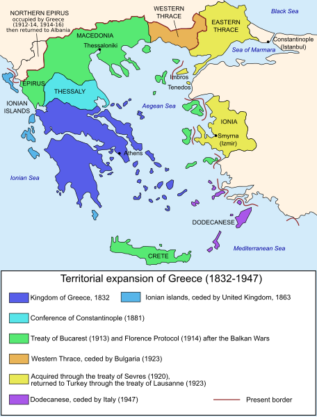
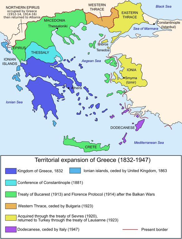
Čeština: Mapa zobrazuje územní expanzi Řeckého království (1832–1947). Dansk: Kort over Grækenlands territoriale udvidelser, 1832-1947. Deutsch: Territoriale Expansion Griechenlands 1832-1947. English: The territorial expansion of Greece, 1832-1947. Español: Mapa de la expansión territorial griega (1832-1947) Euskara: Greziaren lurralde hedapena 1832-1947 bitartean Français : L'expansion territoriale de la Grèce. 1832-1947. Hrvatski: Teritorijalno proširenje Grčke u razdoblju od 1832. do 1947. Italiano: L'espansione territoriale della Grecia dal 1832 al 1947 Magyar: Görögország területi növekedése (1832-1947) Occitan : Evolucions territòrialas de Grècia. Ελληνικά: Η εδαφική επέκταση της Ελλάδας 1832-1947. Македонски: Територијално проширување на Грција Українська: Територіальна експансія Греції (1832-1947). 日本語: ギリシャ王国の版図拡大 (1832-1947年) 中文: 希腊的领土变迁,1832年-1947年间。 العربية : خريطة تُصوِّر الأراضي التي استولت عليها اليونان مُنذُ سنة 1832م حين استقلالها عن الدولة العُثمانيَّة، وُصولًا إلى سنة 1947م |
||||||||
| Date | |||||||||
| Source |
Own work based on: Map Greece expansion 1832-1947-fr.svg References: Ortolland, Didier (2009-04-10). The Greco-Turkish dispute over the Aegean Sea : a possible solution ? [Greece's borders since 1830]. Diploweb. |
||||||||
| Author | Historicair, translator Rursus | ||||||||
| Permission (Reusing this file) |
|
||||||||
| Other versions |
Derivative works of this file: []
|


.PNG)


.png)


File history
Click on a date/time to view the file as it appeared at that time.
| Date/Time | Thumbnail | Dimensions | User | Comment | |
|---|---|---|---|---|---|
| current | 10:27, 27 December 2019 | | 730 × 959 (469 KB) | wikimediacommons>Cplakidas | corrections: N. Epirus was not occupied in 1918-23, but in 1912-14 and 1914-16; eastern Aegean islands were assigned only at the Protocol of Florence in 1914. And vectorize text |
File usage
The following page uses this file: