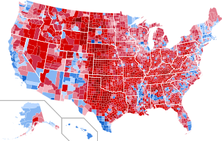
File: 2016 United States presidential election results map by county.svg

Size of this PNG preview of this SVG file: 542 × 334 pixels. Other resolutions: 320 × 197 pixels | 640 × 394 pixels | 1,024 × 631 pixels | 1,280 × 789 pixels | 2,560 × 1,578 pixels.
Original file (SVG file, nominally 542 × 334 pixels, file size: 13.32 MB)
 Any autoconfirmed user can overwrite this file from the same source. Please ensure that overwrites comply with the guideline.
| Description |
English: Results by county of the United States presidential election, 2016.
Clinton—80-90%
Clinton—70-80%
Clinton—60-70%
Clinton—50-60%
Clinton—40-50%
Clinton—<40%
Trump—<40%
Trump—40-50%
Trump—50-60%
Trump—60-70%
Trump—70-80%
Trump—80-90%
Trump—>90%
|
||||
| Date | |||||
| Source |
This file was derived from: USA Counties.svg |
||||
| Author | Ali Zifan and Inqvisitor | ||||
| Permission (Reusing this file) |
|
||||
| Other versions |
[]
|




File history
Click on a date/time to view the file as it appeared at that time.
| Date/Time | Thumbnail | Dimensions | User | Comment | |
|---|---|---|---|---|---|
| current | 02:55, 28 January 2025 | | 542 × 334 (13.32 MB) | wikimediacommons>GatewayPolitics | fix |
File usage
The following page uses this file:
