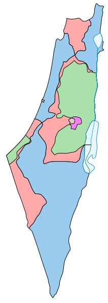
File: 1947-UN-Partition-Plan-1949-Armistice-Comparison.svg

Original file (SVG file, nominally 367 × 1,029 pixels, file size: 48 KB)
This file is from Wikimedia Commons and may be used by other projects. The description on its file description page there is shown below.
Summary
| Description1947-UN-Partition-Plan-1949-Armistice-Comparison.svg |
English: Comparison between the boundaries in the November 29th 1947 United Nations General Assembly partition plan (Resolution 181) for the British Mandate Territory of Palestine and the eventual armistice boundaries of 1949-1950. The meaning of the map colors is as follows (a legend caption is available in template form here):
Some limitations of the map:
|
| Date | |
| Source | This is a partial SVG conversion (omitting text) of the original PostScript vector source of raster Image:1947-UN-Partition-Plan-1949-Armistice-Comparison.png by User:AnonMoos. Apparently, http://unispal.un.org/UNISPAL.NSF/0/651C804E6815FB28852575DF004B7C4C, ANNEX II, is the ultimate (UN) source. |
| Author | AnonMoos |
| Other versions |
Derivative works of this file: Palaestina 1947.svg[edit]
|
Licensing
| Public domainPublic domainfalsefalse |
| This work has been released into the public domain by its author, AnonMoos. This applies worldwide. In some countries this may not be legally possible; if so: |
Captions
Items portrayed in this file
depicts
13 July 2007
image/svg+xml
61992d864cc3b969cdb625ec1db7016f01f9017f
49,350 byte
1,029 pixel
367 pixel
File history
Click on a date/time to view the file as it appeared at that time.
| Date/Time | Thumbnail | Dimensions | User | Comment | |
|---|---|---|---|---|---|
| current | 19:38, 8 November 2013 | 367 × 1,029 (48 KB) | wikimediacommons>Ori~ | Reverted to version as of 16:16, 7 May 2013 |
File usage
The following page uses this file:
Metadata
This file contains additional information, probably added from the digital camera or scanner used to create or digitize it.
If the file has been modified from its original state, some details may not fully reflect the modified file.
| Short title | Comparison between the boundaries in the November 29th 1947 United Nations General Assembly partition plan (Resolution 181) for the British Mandate Territory of Palestine and the eventual armistice boundaries of 1949-1950. |
|---|---|
| Width | 367 |
| Height | 1029 |


